Washington County (Ohio)
County in de Verenigde Staten | |||
 | |||
Situering | |||
| Staat | Ohio | ||
| Tijdzone | Eastern Standard Time (UTC−5) | ||
| Coördinaten | 39°27'36"NB, 81°29'24"WL | ||
Algemeen | |||
| Oppervlakte | 1.658 km² | ||
| - land | 1.645 km² | ||
| - water | 13 km² | ||
| Inwoners (2000) | 63.251 (38 inw./km²) | ||
Overig | |||
| Zetel | Marietta | ||
| FIPS-code | 39167 | ||
| Opgericht | 1788 | ||
Foto's | |||
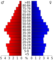 Bevolkingspiramide Washington County | |||
Statistieken volkstelling Washington County | |||
| |||
Washington County is een van de 88 county's in de Amerikaanse staat Ohio.
De county heeft een landoppervlakte van 1.645 km² en telt 63.251 inwoners (volkstelling 2000). De hoofdplaats is Marietta.
Bevolkingsontwikkeling
| Historische inwonertallen | |||
|---|---|---|---|
| Jaar | Inwoners | % ± | |
| 1900 | 48.245 | — | |
| 1910 | 45.422 | −5,9% | |
| 1920 | 43.049 | −5,2% | |
| 1930 | 42.437 | −1,4% | |
| 1940 | 43.537 | 2,6% | |
| 1950 | 44.407 | 2,0% | |
| 1960 | 51.689 | 16,4% | |
| 1970 | 57.160 | 10,6% | |
| 1980 | 64.266 | 12,4% | |
| 1990 | 62.254 | −3,1% | |
| 2000 | 63.251 | 1,6% | |
| Bron: (en) Historical Decennial Census Population | |||
| County's in Ohio |
|---|
Adams County · Allen County · Ashland County · Ashtabula County · Athens County · Auglaize County · Belmont County · Brown County · Butler County · Carroll County · Champaign County · Clark County · Clermont County · Clinton County · Columbiana County · Coshocton County · Crawford County · Cuyahoga County · Darke County · Defiance County · Delaware County · Erie County · Fairfield County · Fayette County · Franklin County · Fulton County · Gallia County · Geauga County · Greene County · Guernsey County · Hamilton County · Hancock County · Hardin County · Harrison County · Henry County · Highland County · Hocking County · Holmes County · Huron County · Jackson County · Jefferson County · Knox County · Lake County · Lawrence County · Licking County · Logan County · Lorain County · Lucas County · Madison County · Mahoning County · Marion County · Medina County · Meigs County · Mercer County · Miami County · Monroe County · Montgomery County · Morgan County · Morrow County · Muskingum County · Noble County · Ottawa County · Paulding County · Perry County · Pickaway County · Pike County · Portage County · Preble County · Putnam County · Richland County · Ross County · Sandusky County · Scioto County · Seneca County · Shelby County · Stark County · Summit County · Trumbull County · Tuscarawas County · Union County · Van Wert County · Vinton County · Warren County · Washington County · Wayne County · Williams County · Wood County · Wyandot County |


