Pierce County (Washington)
County in de Verenigde Staten | |||
 | |||
Situering | |||
| Staat | Washington | ||
| Tijdzone | Pacific Standard Time (UTC−8) | ||
| Coördinaten | 47°3'0"NB, 122°6'36"WL | ||
Algemeen | |||
| Oppervlakte | 4.678 km² | ||
| - land | 4.348 km² | ||
| - water | 330 km² | ||
| Inwoners (2000) | 700.820 (161 inw./km²) | ||
Overig | |||
| Zetel | Tacoma | ||
| FIPS-code | 53053 | ||
| Opgericht | 1852 | ||
Foto's | |||
 Bevolkingspiramide Pierce County | |||
Statistieken volkstelling Pierce County | |||
| |||
Pierce County is een van de 39 county's in de Amerikaanse staat Washington.
De county heeft een landoppervlakte van 4.348 km² en telt 805.400 inwoners (2007). De hoofdstad is Tacoma. In Pierce County ligt de hoogste berg van de Amerikaanse Westkust, de stratovulkaan Mount Rainier (4392 m).
Bevolkingsontwikkeling
| Historische inwonertallen | |||
|---|---|---|---|
| Jaar | Inwoners | % ± | |
| 1900 | 55.515 | — | |
| 1910 | 120.812 | 117,6% | |
| 1920 | 144.127 | 19,3% | |
| 1930 | 163.842 | 13,7% | |
| 1940 | 182.081 | 11,1% | |
| 1950 | 275.876 | 51,5% | |
| 1960 | 321.590 | 16,6% | |
| 1970 | 411.027 | 27,8% | |
| 1980 | 485.643 | 18,2% | |
| 1990 | 586.203 | 20,7% | |
| 2000 | 700.820 | 19,6% | |
| Bron: (en) Historical Decennial Census Population | |||
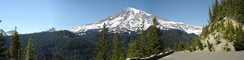
Mount Rainier
| County's in Washington |
|---|
Adams · Asotin · Benton · Chelan · Clallam · Clark · Columbia · Cowlitz · Douglas · Ferry · Franklin · Garfield · Grant · Grays Harbor · Island · Jefferson · King · Kitsap · Kittitas · Klickitat · Lewis · Lincoln · Mason · Okanogan · Pacific · Pend Oreille · Pierce · San Juan · Skagit · Skamania · Snohomish · Spokane · Stevens · Thurston · Wahkiakum · Whatcom · Whitman · Yakima |
| Zie de categorie Pierce County, Washington van Wikimedia Commons voor mediabestanden over dit onderwerp. |


